
Since 1965, Singapore has grown from 224.5 to 276.5 square miles through the movement of sand from various Southeast Asian origins to its outlying islands and coasts through land reclamation.1 Amongst its busy seaport traffic, one observes the ever-present sand barge – it tugs along a super highway for sand, the very sand that claims not to have a history, ghosts and stories, but it does. There is also another issue: this sand continues to move under the assumption that an inherently finite resource can be made to appear limitless. It is an alteration of the manner in which the state and what it governs may be imagined. It is reminiscent of another ‘geo-logic’: as this newly reclaimed land is not inherited, but proclaimed. This reclaimed land, it is also said, is without history: an unclear past but of critical contemporary presence; it may even be a fearless land, where the present is said to meet the imagination.
This transcript is an edited version of a conversation between Charles Lim, a sailor turned artist whose concerns have centred on water bodies in relation to land, and Foo Say Juan, a figure who worked as a sand surveyor in Southeast Asian waters during the 1990s. This conversation centres on Lim’s attempts at unravelling the regional and international genealogies of sand that make up land reclamation efforts in Singapore. Simultaneously, the conversation also drifts into questions of materiality, as Lim seeks data in the form of recollections and anecdotes from his interviewee into the types of submarine man-made infrastructures that exist under the sea.2 Yet, the dialogue also addresses the interviewee Foo’s attempt at offering an oral history into the process and scientific methods involved in sand surveying, opening up questions into how scholars may begin to think about the ‘infrastructural’ and the ‘industrial’ in Singapore. Could sources such as these be a means through which we unravel how Singapore has become a geophysical force in the period of the Anthropocene, a work-in-progress term for this current epoch when human activities globally have had a significant influence on the Earth’s bionetworks.
Singapore is now a human island.
Shabbir Hussain Mustafa
[Sentosa Cove, One Degree North Marina, aboard the Boon Teik. 2nd February 2015.]
Charles
…I think this must be the third time that we are talking about this. The first time was many years ago when you shared your story with me. I recorded it then, but to be honest I have lost the file.
Foo
I will try to recall the things I did in the ‘90s, the time when many landfill projects were ongoing in Singapore. The biggest was around the Southern Islands, where the oil refineries are, when so many of the islands were merged and linked together. This was followed by the Pasir Panjang container wharf project in the southwest of Singapore. During the time they needed a lot of sand, and our company was fortunate enough to be the one called in to look for the sand. What would happen is that the main contractor would gather together the information we had secured, and then suck the sand into the barges, followed by delivery to Singapore. The areas we chose for sand searching are nearby islands, like Karimun, and towards the east, which is Durian Island, and even further east, near Batam, Indonesia. The furthest we went was Batam. Although the project looks complicated, it actually used simple technology. But we also had to use much more advanced equipment like DGPS. We did not use GPS because the difference in measurement with GPS can be up to five to ten metres. So we used DGPS because the project needed accuracy and precision in terms of identifying the quality and quantity of sand. Each time we went out to look for sand, we spent up to one month on board the ship. Most of our efforts were spent doing the landfill projects of Pasir Panjang and the southern islands, which are Ayer Chawan, Pulau Sekai and so on.
Charles
The ship that you were on, was it a survey ship?
Foo
It was actually not a survey ship, it was a utility vessel. The important thing is the equipment. For example, we needed an A-frame, which is a structure with an A-shape attached to the drop core. The drop core is a stainless steel instrument that is probably about five to eight metres long. The A-frame must be attached the drop core; we call this instrument a drop core because there is a core in the middle of the shaft. When we release the drop core, it penetrates into the sand due to the weight of the metal and it is made in the form of a long arrow. The tip is tapered so it can penetrate deeper into the sand. There is a core in the middle, which when dropped, penetrates about five metres into the sand, and when we pull it back up into the transom of the vessel, there is a locking device along the core. From that point onwards, we open up the core and we will have four or five metres of sand trapped inside. Usually there are only three types of elements that we see: clay, silt or sand. Of course we prefer sand because sand is the best element. Usually if we hit clay, the penetration of the core will only be one metre. But when we hit sand, it probably goes up to four to five metres. The sand is then collected in the form of a one-metre, two-metre or three-metre quality. The final step is to save the coordinates and positions. Then we travel a nautical mile further away and drop the core again.
Charles
So what is considered good or bad sand?
Foo
Sand is normally coarse or fine. Both are all right for the landfill. The main contractor was not keen on a mixture of silt and sand. From the developer’s perspective, silt would not give a firm foundation. Sand, however, will eventually become compact.
Charles
When you did the surveys, was there a ship that followed you or were you out there on your own?
Foo
You only need one vessel to search and check the quality of sand. The boat is usually 100-foot long because we lived on board. We needed the crew, a captain, technicians and a survey team. Then we also had divers; so should the drop core get stuck in the clay and we cannot pull it back up for some reason, the divers would go down and settle the problem. And this does happen, but of course when it happens, we would need to have some cores on standby. Usually when the drop core has been stuck in clay, it gets bent by the time it is retrieved. So we have to replace it in a short period of time. The commercial divers are very efficient. They can do welding jobs on board, do any repairs on the vessel, at any time.
Charles
Were there instances when you found something you did not expect?
Foo
Well, this was a straightforward sand search. Once we have the quality of sand noted down per nautical mile, the main contractor, at times, would request, “The amount and quantity of sand is recorded, but to play it safe, can you do another survey?” We call this a magnetic survey and this is a scan done with a different set of instruments. About a metre above the seabed, we conduct a scan for any magnetic objects that may be resting on the surface or close to it. Usually for this type of sea area, we do not see many unusual objects. But we usually check for World War II remnants like cannons. They could be big cannons, mortar shells, or a bomb. So what we would do is conduct the scan and detect the magnetic spot, then we pass this data and the coordinates of the magnetic spots on to the main contractor. They would often request further, “Can you check what it is?” We would then check what exactly the magnetic equipment or material is, take a picture and remove it if possible. We would dump it in the designated dumping ground, usually around Batam. The designated dumping area is always indicated on the charts. For magnetic surveys, we did not use the big vessel. We used a smaller craft.
Charles
So can you dump anything there?
Foo
Correct.
Charles
Are there a lot of things in the dumping area now?
Foo
I have no idea, because normally we would just drop the object and be off.
Charles
Let’s say you find a bomb, how would you move it?
Foo
We would not bring it onto the boat. We would pull it onto the surface of the water and slowly tow it to the dumping area. So actually there is a risk factor involved.
Charles
Did anything happen when you were towing?
Foo
So far, I think that is how it is done. They will not bring the bomb, for instance, to land. It is a big headache for the land authorities.
Charles
So the dumping ground is not in Singapore?
Foo
No. It is around the area that we are surveying, depending on where the location is.
Charles
Is it on the charts produced by the Maritime and Port Authority of Singapore?
Foo
No, because we cannot bring the item back to Singapore.
Charles
How often do you find such ordnances?
Foo
It is very common especially around this area. We do not bring back such items. We see it down there, we have to retrieve and dispose of it at the dumping ground. The items could be old machine guns with the rounds still in them, and sometimes it could be mortar shells or explosive items, sometimes even old engines. We are more concerned about the bombs, because when we want to suck up the sand, sometimes the bomb might get sucked in together with the sand and it could explode inside the suction pipe. This could cause a delay in the operation.
Charles
Has that happened before?
Foo
Yes. Sometimes it could get stuck at the mouth of the suction and damage the equipment. At the same time it could disrupt the operation. So our main concern is to move the explosive to the dumping ground so the operation for the suction of sand will not be affected.
Charles
I think the bombs are something left over from the colonial period. I mean we find newspaper articles, of this kid in the ‘90s who found a bomb on the beach of newly reclaimed land and got killed because the bomb exploded…?
Foo
After that they were aware of the dangers of unexploded ordnances in transport over by the barges, and later onto the landfill island. Therefore, we are required to remove it before the operation starts.
So is the magnetic survey conducted using a smaller vessel?
Yes. When they conduct the magnetic search, I do not have to be involved because my job was more on the computer screen, where I map the sand area, the quality of sand and the recording of the sand search.
Charles
Do you still have the sand surveys charts with you?
Foo
No. It has been over 20 years.
It would be interesting to see how you mapped it out.
It’s quite simple. I’m sure you understand about the sort of software that GPS is based on, right? So you have the GPS in front of you with the vessel indicated, and what we did was plot the square lines on the GPS. You call it a grid. Each nautical mile is one grid. When we conduct the survey, when we drop the core, it will be according to the grid, because you will be able to pinpoint the vessel on the GPS. So when you move according to the grid line – also called a way line – on the GPS or DGPS, we drop the core, and I have to record the spot coordinates. From that point onwards, we retrieve the core and each sample will be numbered. All of this will have to be written on the cans containing the sand. For example ‘A1 coordinates’, then samples for A2 will be recorded with ‘A2 coordinates’ and so on.
Charles
You did the reclamation for some of the Southern Islands and Pasir Panjang. Do you know which location the sand came from?
Foo
I roughly know which areas of the sea, but of course we did not monitor the exact location of the sand. The interesting part is the work involved. Not many people know that sand search or landfill projects require such technology where you have to look for sand, and especially how the quality and quantity of sand is checked. The interesting part is the process and how we carry it out. After the landfill projects we also used our knowledge for projects such as the retrieval of the 1997 SilkAir crash in Palembang. Oddly, it’s almost the same process but we did not need instruments to suck the plane up. The dredgers went there instead. It was a matter of mapping the coordinates and then the retrieval. The dredgers also use the same method when the scoop goes down to retrieve the plane, where they pull up and place the debris onto the barge which has netting on top. What they do is use high water pressure from the sea and the silt will settle down onto the barge. The remains will be stuck on the netting.
Charles
When we spoke years ago, you said you were apprehended by Indonesians when conducting sand surveys. Maybe you can tell us how that happened…
Foo
Sometimes it is very sensitive. Once in Kukup, Malaysia, we had a navy vessel check our permit, and we did have the permit to do the dredging work. Eventually they left the vessel. It is political. In Indonesia, we got held back for a month.
Charles
Which year was this?
Foo
In the ‘90s. We went to do a survey, but I think we did not have a permit or the main contractor did not arrange for one. Then we were held and lived there for a month; waiting for permits, waiting for approval to continue the project.
Charles
Where you held on the boat?
Foo
When a navy vessel approaches the vessel and considers it suspicious, they would ask the vessel to follow them back to the naval base. Normally that is how it works. Then once you are at the naval base, they will check the permit and so on.
When you were held, did you have to stay on the ship?
Charles
We did not have to because we were not criminals. We were trying to do a job and sometimes it is solely based on permit issues. So the only thing is that our passports were confiscated. We could not leave the country but were free to move around.
Foo
So what did you do for one month?
Charles
We visited quite a number of interesting places in Indonesia.
Foo
I find interesting that you were there doing a job, and suddenly you had nothing to do. So what did you do?
Well, there is nothing we could do; we had to wait for the permit and the application to be approved. We had to settle some fines that were imposed. But during that period we didn’t know how long it would take, and they told us, “It will take two weeks, why not go and relax?” What I did was I went to Jakarta. Indonesia was hosting the Southeast Asian Games in Jakarta at the time. So I went to the games village, visited my friends for a day or two. I became very familiar with Jakarta because we were there for a couple of weeks, so I brought some of my Singaporean friends who were in Jakarta around too.
Charles
So is this checking of permits very common?
Foo
Sometimes we never know what is required. Sometimes we may have a permit but we infringe on other authorities. So sometimes they say, “Oh, you need another permit, this is not enough.” So we have to comply with the rules, probably pay the fine and then continue with the job.
Charles
So were most of the people on the boat Japanese or Singaporeans?
Foo
We had a mixture of Japanese and Singaporeans.
Charles
How many ships were there?
Foo
There were not many companies doing sand search projects.
Charles
Who has the data from the sand surveys that you conducted?
Foo
Normally we do not hold on to those samples. As soon as we find the sand, we map the area, and the information of the sand is recorded. The quality is exactly the same as the samples we collected. After that we just dispose of the sand. Finally the sand would be sucked up and delivered to the landfill site.
Charles
How much sand do they take?
Foo
Sand is natural; you will not affect the geographical area of the island.
Charles
What about the sand from Singapore?
Foo
Well, as you know, sand in Singapore is not natural sand. If I’m not wrong, you can look around in Singapore, it usually has a silt base. Once you have sand, you will be able to see crystal clear water. That is why you hardly see crystal clear waters in Singapore, because underneath it is silt.
Charles
And what causes the silt?
Foo
The silt is natural. Look at the Maldives, you do not see silt. In Singapore, we are surrounded by water and under the water is all silt, which you can never convert to sand.
Charles
When they did the land reclamation project, there were a lot of shores with sea grass. They dumped the sand on top of it and affected the sea grass…?
Foo
To boaters, sea grass is not favourable because it gets caught in the filter. So many times they try to get rid of the sea grass. Especially in Sentosa, where we are right now, there is a lot of it. They are thinking of ways to get rid of it because it’s not good for corals; it takes away the oxygen and nutrients.
Charles
I remember from our earlier conversations that when you were doing the surveys, there would be rival companies trying to leech onto your survey data…?
Foo
There were some other companies but they used the ship method rather than barges. The ship method is random. They would randomly put the suction pipe right at the bottom of the seabed and suck. Sometimes they probably brought in a lot of silt into the vessel, because they did not know what the quality of the sand was before they began the suction.
Charles
Were these rivals following your survey ship?
Foo
I do not think so. They probably knew we are doing surveys but they were not in the same area.
Charles
What was the cost of sand during that time?
Foo
I have no idea. What is good to understand is the process. It is actually something not understood by many people. How the land is filled, how the project works. It will be good to let the young generation understand how this technology and process is carried out.
Right now Sentosa Cove is reclaimed land. Most countries when they talk about land, there is some connection to the land. Nations are very connected to land, but I think in Singapore, land is not something that we inherit but something that we build. It is not passed down, but it is actually made. Say a site that you were involved in the process of finding the sand, how does that land relate to you? Do you feel a sense of connection to it?
We have this feeling that there is a need to have more land. When land area is constrained, and if the authorities want to develop more space, then of course landfills are great. The land can be expanded and can be created for leisure or industrial purposes. So sometimes you feel that, “Oh, it’s a good idea!” Using sea sand which if we did not use, will be a waste. You use the sea sand to expand and enlarge the island. You find that this should be the way. In the ‘50s and ‘60s, during those days, they did not use this method. They used highland soil and transported it by truck to refill the land. That was not economically wise and you needed a lot of trucks, manpower, and equipment. How much can a truck carry each time? Sea sand is so simple. You only need to suck the sand into the barges and you do not need to worry that once the sand goes into the barges it will sink down. Once the barges are full, water will spill over and the sand will be delivered to Singapore in one boat –100-foot barges all the way to the site. So it is cheaper, and economical. I find it is good to continue growing the island because Singapore is too small.
Charles
Do you have any personal relics or photographs?
Foo
No, I do not keep any.
Charles
No mementos, nothing?
Foo
No.
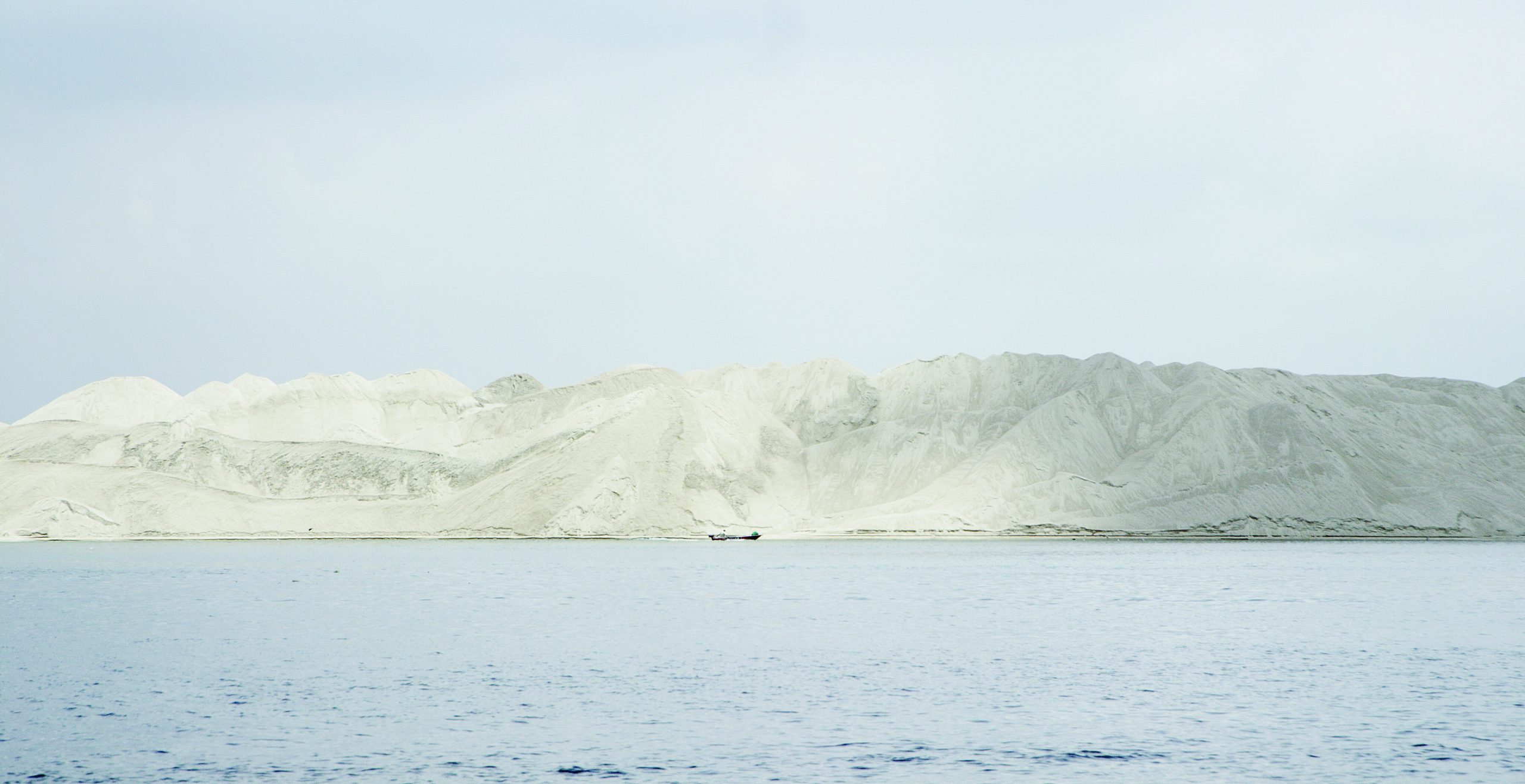
Charles Lim, SEA STATE 7: sandwich (production still), 2015.
Image courtesy of the Artist
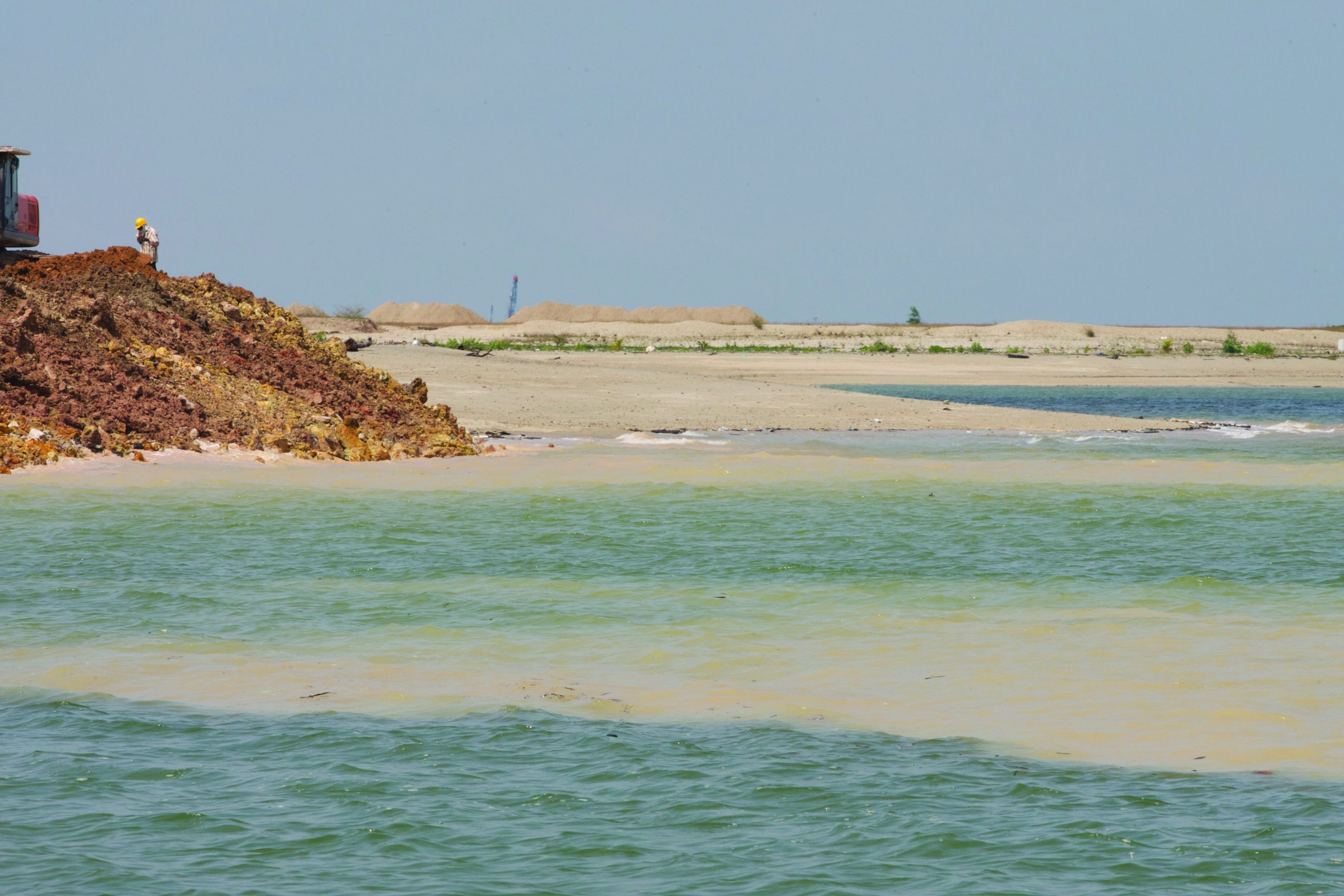
Charles Lim, SEA STATE 7: sandwich (production still), 2015.
Image courtesy of the Artist